LOCATION OF THE BERKSHIRE AND MARLBOROUGH DOWNS
The Berkshire and Marlborough Downs spread across the northern North Wessex Downs Area of Outstanding Natural Beauty (AONB), which encompasses much of West Berkshire and parts of Oxfordshire, Hampshire and Wltshire, from its northern boundary overlooking the Vale of White Horse south to the valley of the River Kennet. The two Downs are part of the Southern England Chalk Formation which runs across the country from Dorset to Kent. There is no universally recognised boundary between the two Downs but it is convenient to assume the boundary to be along the M4 corridor north of junction 14.
Around the village of Lambourn, especially the higher ground to the north of the village, the Downs become the Lambourn Downs, and sometimes elsewhere local names are used, e.g. south of Blewbury there is Blewbury Down and, further west, the well-known White Horse Hills.
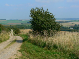
View east to the Marlborough Downs (copyright Brian Robert Marshall)
(licensed for reuse under the Creative Commons Attribution-ShareAlike 2.0 Generic (CC BY-SA 2.0) license
|
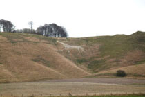
The northern edge of the Downs has the steeper scarp slope and there is a virtually continuous ridge of high ground. In the west there is another distinct scarp slope at Hackpen Hill north-west of Marlborough. These ridges are on the route of The Ridgeway trail, the original trail which extends from near Avebury in Wiltshire to the River Thames at Goring Gap.
South of these ridges the Downs are divided by the valley of the River Lambourn and the valleys of other small rivers and streams. The more open downland scenery is confined to the northern and central areas of the Downs, whereas in the south the hills are generally lower and gently undulating with areas of woodland.
In the west the AONB and the Marlborough Downs extend almost to Calne in Wiltshire and in the east the Berkshire Downs spread to the valley of the River Thames which separates them from the Chiltern Hills. The picturesque Goring Gap, where the River Thames separates Streatley from Goring, is where the Berkshire Downs and the Chilterns are at their closest.
Click here for the North Wessex Downs Area of Natural Beauty website which contains a map showing the location of the Berkshire and Marlborough Downs |
RIVERS OF THE BERKSHIRE and Marlborough DOWNS
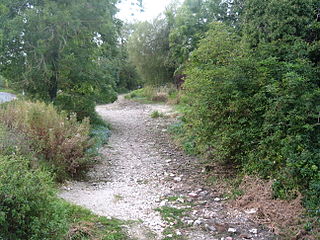
The most notable rivers that originate and cut through the downs are the River Pang and the River Lambourn, both of which are little more than streams. They are chalk streams and their upper reaches, together with their smaller tributaries, are winterbournes which means they are often dry in the summer when rainfall is low. The Pang's source is near the village of Compton and it flows for some 14 miles to join the River Thames at Pangbourne. The source of the 16-mile long River Lambourn is close to Lambourn village high in the Downs and it joins the River Kennet at Newbury.
Two of the smaller streams are the River Og which flows for about 4.5 miles from near the village of Ogbourne St. George south to meet the River Kennet at Marlborough, and the River Aldbourne, roughly the same length, which flows from the village of the same name to the River Kennet.
THE ECONOMY OF THE BERKSHIRE and marlborough DOWNS
|
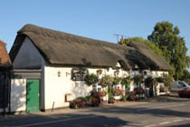
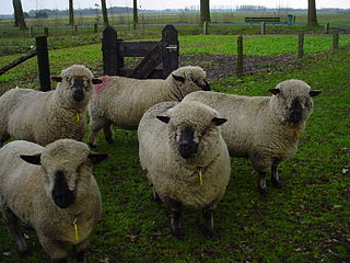
The downland pasture is firm and well drained, suited to grazing sheep and grazing and training horses. Sheep-grazing on the downs was once extensive and the village of East Ilsley once held an important weekly sheep market, the second largest in the country, and had claims on the title of sheep farming capital of England.
Berkshire once had its own breed of sheep, the Berkshire Nott Wether but the breed is now extinct and the Hampshire Down sheep is a direct descendant. Sheep grazing still continues in the Downs, but on a smaller scale and much of the land is nowadays given over to cereal production. Areas of woodland in the Downs tend to be small, unlike in the Chiltern Hills where beech woods were once important to the local economy.
A flock of Hampshires
(Licensed for reuse under the Creative Commons Attribution-ShareAlike 2.0 license)
|
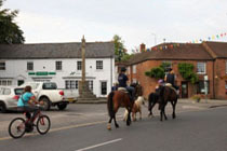
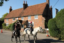
Horse racing is a major business in parts of the Downs and several of the upland villages are home to major racing stables. In and around Lambourn, the most notable of these villages, there are over 1,000 horses in training, and over 50 racing yards. Much of the higher parts of the Downs, especially the Lambourn Downs, is made over to gallops and other training areas. The Lambourn Valley, one of the main training centres in England, is known as The Valley of the Racehorse. Racing stables are not confined to the Lambourn area however and elsewhere in the Downs there are several smaller establishments.
Elsewhere in the Downs arable farming is more important, especially cereals, and in late summer the Downs are golden as the harvest gets under way.
A racehorse and gallop (copyright Richard Greenwood)
(Licensed for reuse under the Creative Commons Attribution-ShareAlike 2.0 license) |
_-_73387.jpg) |
ANTIQUITIES IN THE BERKSHIRE and marlborough DOWNS
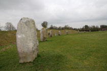
Throughout the Downs there are Neolithic, Bronze and Iron Age prehistoric sites, including the Wayland's Smithy, Uffington White Horse, Uffington Castle, Liddington Castle, Segsbury Camp, Grim's Ditch in the Berkshire Downs. In the Marlborough Downs prehistoric sites include the Avebury Henge and stone circles, the mysterious Silbury Hill, West Kennet Long Barrow, Barbury Castle and a number of white horses cut into the chalk on the hillsides. Throughout the Downs there are numerous tumuli.
The Ridgeway, described as Britain's oldest road, is an ancient track which extends from Avebury along the ridge of the downs to the River Thames at Goring Gap. Now one of the country's National Trails, The Ridgeway trail carries on across the Thames and follows the Chilterns to Ivinghoe Beacon in Buckinghamshire.
|
Silbury Hill, Wiltshire (copyright Greg O'Beirne)
Licensed for reuse under the Creative Commons Attribution-Share Alike 3.0 Unported, 2.5 Generic, 2.0 Generic and 1.0 Generic license. |
|
Uffington White Horse (NASA)
USGS [Public domain], via Wikimedia Commons |
Barbury Hill Iron Age Fort (copyright Geotrekker72)
(Licensed for reuse under the Creative Commons Attribution-ShareAlike 4.0 International license) |
|
 copy.jpg)
.jpg)
.jpg)
.jpg)
.jpg)
.jpg)
.jpg)
.jpg)
.jpg)
.jpg)
.jpg)
.jpg)
.jpg)
.jpg)
.jpg)
.jpg)
.jpg)